


Precinct 1-3, Catahoula Parish, Louisiana
About
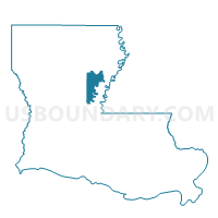
Outline

Summary
| Unique Area Identifier | 588429 |
| Name | Precinct 1-3 |
| County | Catahoula Parish |
| State | Louisiana |
| Area (square miles) | 11.46 |
| Land Area (square miles) | 10.48 |
| Water Area (square miles) | 0.98 |
| % of Land Area | 91.45 |
| % of Water Area | 8.55 |
| Latitude of the Internal Point | 31.71562250 |
| Longtitude of the Internal Point | -91.78173180 |
Maps


Graphs
Select a template below for downloading or customizing gragh for Precinct 1-3, Catahoula Parish, Louisiana


Neighbors
Neighoring Voting District (by Name) Neighboring Voting District on the Map
- Precinct 1-1, Catahoula Parish, LA
- Precinct 1-4, Catahoula Parish, LA
- Precinct 2-2, Catahoula Parish, LA
- Precinct 2-5, Catahoula Parish, LA
- Precinct 6-1, Catahoula Parish, LA
Top 10 Neighboring County Subdivision (by Population) Neighboring County Subdivision on the Map
- District 4, Catahoula Parish, LA (1,909)
- District 5, Catahoula Parish, LA (1,286)
- District 2, Catahoula Parish, LA (1,131)
- District 6, Catahoula Parish, LA (1,050)
- District 1, Catahoula Parish, LA (767)